
Hiking Mount Nebo Utah Highest Peak in the Wasatch
Hiking Mount Nebo, Utah’s Highest Peak in the Wasatch! If your plan is to summit the highest mountain in the Wasatch you had better go prepared. With over 16 miles, 5,249ft of elevation gain, and NOBODY around, this mountain offers a challenge that’s worthy of it’s elevation. (11,929ft)
")
Hiking Mount Nebo Utah
BOOM! CRACK! The thwack of hailstones pelted our faces as we ran down Mount Nebo seeking the shelter of our parked car. I knew that summiting the Highest Peak in the Wasatch would be a challenge.
The day started off at the crack of 5 am. Finding the Andrews Ridge trail was fairly easy. From the parking lot, the view of Mount Nebo is partially obstructed but you can get a glimpse of the North peak towering way overhead. We started with high spirits and our hearts ready for adventure. Ignorance is bliss and the beginning of the Andrews ridge trail is too. The trail is fairly steep but smooth and well maintained. Soon though, after your cardiovascular switches from anaerobic to aerobic, your pace will slow immensely due to overgrowth that has hidden the trail. There is a trail under all the scrub oak but it’s slow going and painful wading through the notorious stabbing branches of the scrub oak. Backcountry skiers rue the scrub oak! A little advice is to wear pants on this trail no matter what the temps are. Pants protect your legs from the scrub oak, biting bugs, and leaf debris in your socks. The bushwhacking doesn’t last too long though. The trail is mostly well maintained but has some obstacles across it. The sun exposure, altitude, and distance are the REAL obstacles on Nebo. There are a couple of small seasonal stream crossings high up on the mountain that likely aren’t there in the late summer months and the fall. If you have a water filter you can secure more water for the summit push. When we made it to the ridge it felt like we had climbed the mountain but there were still 2 miles to go. This is where we could start to notice small symptoms of High Altitude Pulmonary Edema (HAPE). Most notably our fingers had slightly swollen and resembled sausages. About this time I would have crushed sausages if I had any that weren’t attached to my hands. We made it up to the summit in 5hours 28 minutes. Not bad but this was only the halfway point. The trail to the summit only required STEEP hiking, with no scrambling involved.
On the way down the pain of our fatigued legs was occasionally interrupted by the incredible smell of wildflowers. Sometimes we’d round a corner and the cool fragrant air would hit us like we had just walked into an air-conditioned flower shop. Incredible views, incredible smells, and most incredibly we hadn’t seen a single person on mount Nebo all day. Further down the mountain anxiety built as we realized that we might make a whole day in the Wasatch without seeing another person. After finding the trail and bushwhacking our way back through the overgrown section, we began to hear the booms of thunder in the distance. We were close enough to the bottom and the shelter of the car that the potential of a passing thunderstorm didn’t pose much of a threat. Suddenly thwack, thwack, thwack hailstones began to pummel us. We made shelter under a tree to wait out the storm. The storm continued to pour harder and we were getting wet and cold. Mount Nebo wasn’t going to let us off easily. When a small river flowed past us down the hiking trail we decided to abandon our paltry shelter. We ran and slid our way down the muddy trail back to the shelter of our parked car. Tired beyond belief, soaking and shivering cold, we did it!
Mount Nebo is a BIG mountain! The sounds of the woodpeckers and the smells of the wildflowers highlighted the trail! Remarkably, we didn’t encounter another person!
Access
Mount Nebo (11,929ft) the highest peak in the Wasatch Range is located just outside the town of Nephi. Nebo is the Southern-most peak in the Central Rocky Mountains of Utah. South of Mount Nebo are the high plateaus of Central Utah which is a different geophysical province.
–Nebo bench trailhead (9,251ft) is located on the North-East slope. The trailhead is located at the highest point on the Nebo Loop Rd. Start along the Nebo bench trail and immediately branch off and route-find your way up to the North Peak (11,174ft) Total Elevation Gain (1,923ft)
–Willow Creek Canyon (6,561ft) This is the main trailhead for people hiking Mount Nebo. From the end of Willow Creek Canyon, road is the beginning of the trail. It heads up a pine-forested slope. The trail meets the main ridgeline at (10,712ft). From here head North on the ridgeline to the summit of the South Peak (11,879ft) Distance 6.21 miles Elevation Gain 5,249ft Time Estimate 4-7hrs
–Andrews Ridge (6,561ft) This is the second most used trail for hiking Mount Nebo. To get there from I-15 take exit 225. Head immediately east. Drive Salt Creek Canyon on Highway 132 toward Fountain Green and Nebo Loop Rd. Or drive the Nebo loop Rd from the North until you arrive at Andrews Ridge trailhead There is a designated parking area you will see from the road. The Andrews ridge trail is the longest of the three summit trail options Distance 8miles Elevation Gain 5,249ft Time Estimate 5-8hrs (each way)
 Mount Nebo topo map
Video Hiking Mount Nebo (Andrews ridge)
Camping
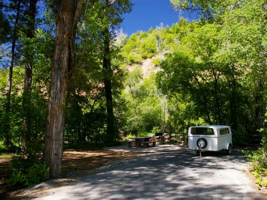
Ponderosa Campground
Restrooms and developed campsites. No hookups for RVs. Close to Andrews Ridge trailhead. We stayed here and it is a nice campground. Be aware that staying here on a weekend WILL require a reservation. RESERVATIONS camping? I think reservations for camping is just wrong. As long as you stay on a weekday you’ll be fine W/O.
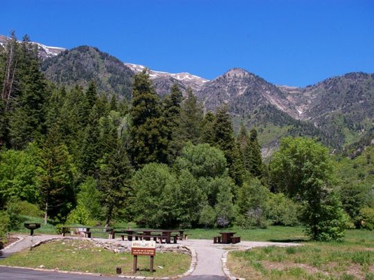
Bear Canyon Campground
This is a fully developed campground minus RV hookups, drinking water, and shade. The views of the mountains are great and unobstructed by trees. This campground is close to the Andrews Ridge trailhead.
Related Articles and links:
If you like this sort of stuff, Like us on Facebook
Park City People YouTube
")
")
")
")